As an avid cyclist and with some free time on my hands after completing a bike tour through Denmark, I set out to ride three iconic climbs featured in the Tour de France: Mont Ventoux, the Col de Galibier, and Alpe d’Huez. I started the challenge with a respite on the picturesque Côte d’Azur. Here’s my account of climbing the Giant of Provence, Mont Ventoux.
The Challenge #
Mont Ventoux is situated in central Provence, approximately 30 kilometers east of Avignon. Its distinctive profile makes it easily identifiable while approaching Avignon on the Autoroute du Soleil en route to Marseille. The mountain offers three primary starting points: Bedoin, Malaucene, and Sault. However, riders embarking from Bedoin will encounter the most challenging ascent – the one used for the Tour de France. Consequently, I opted to begin my climb from Bedoin. As the gateway to this formidable climb, Bedoin has undergone a certain transition as a cyclists basecamp. The town boasts excellent restaurants and offers free parking facilities for cyclists with minimal hassle.
While altitude is indeed a factor that contributes to the difficulty of Mont Ventoux, there are other challenges that riders must contend with. The road’s gradient can reach as high as 10% in certain sections. Furthermore, the Mistral wind – a hot and fast gust blowing from the Mediterranean at speeds of up to 200 km/h for most of the year – adds an extra layer of complexity. This is accompanied by the soft and chilly Provençal breeze, which can make the temperature fluctuations even more pronounced.
The heat is another significant challenge on this climb. Temperatures often soar above 40 degrees Celsius during the ascent. However, it’s not just the physical conditions that require attention; the breathtaking scenery also demands regular stops or cut-throat in-ride camera handling to take in the views. The “Col de les Tempêtes” offers a particularly striking vantage point, where riders can pause and appreciate the area’s beauty.
The ascent from Bedoin #
As you exit the last roundabout in Bedoin, you’ll embark on a lengthy straight stretch that winds its way through a picturesque landscape, offering a yet gentle gradient to ease you into the climb. Some riders may be tempted to push their limits here, while more experienced cyclists will judiciously pace themselves, aware that the mountain still holds many challenges and mid-bosses ahead.
After a few kilometers of this relatively flat section, you’ll reach a bend that marks the beginning of a 10-kilometer stretch through forested terrain. Just before the turn, there’s a fountain – a welcome oasis where you can replenish your hydration levels or even soak your jerseys in water (alas, I didn’t take advantage of this opportunity). Be sure to top off your bottles here, as the next chance to refill won’t come until you emerge from the forest.
I strongly advise carrying at least two, if not three, bottles of water on this ride – especially on a hot summer day. Anything less would be akin to entering a battle ill-prepared; it’s simply not enough for the ascent that lies ahead.
The forest #
As you enter the 10km stretch of forested terrain, be prepared to face a climb under the scorching sun with minimal wind to manage your body temperature to your favor. The gradients will test your limits, and the presence of other riders fighting their way up the mountain won’t make it any easier. To add insult to injury, the sound of overheating clutches and brakes from cars laboring their way up will be a constant reminder that you’re not alone.
With a road bike designed for speed and a transmission geared towards rapid ascents, I found myself compelled to maintain a higher pace than I would have liked in order to keep my cadence above 70rpm. Unfortunately, there’s little opportunity to coast or recover during this stretch – the relentless gradient demands that you stay focused.
To conserve energy for the challenges ahead, I employed a strategy of slowing down and taking brief respite in the few shadows cast by trees along the side of the road. On two separate occasions, I performed track stands, hoping to cool down and recharge my reserves. As I stood still for 20 seconds in a larger shadow before a bend, my bike computer indicated an outside temperature of 39°C (103°F) and a heart rate well within the yellow zone – should be fine.
I must extend my gratitude to the woman who was kind enough to spray water from her pistols at cyclists to help keep them cool. I’d also like to offer best wishes to the couple getting married here today, as evidenced by the proposals written to the road surface. Additionally, I’d like to express appreciation for the enthusiasm of the Dutch cycling fans who displayed a large “hup” banner in support of their team. And finally, respect must be given to the Danish cycling fans who created an impressive Dannebrog (the Danish flag) across the road – no small feat considering they managed to do so without being ran over.
As you exit the forest, you’ll face yet another uphill stretch, with a restaurant situated on your right-hand side. This is your last chance to refill your water bottles before reaching the summit. If you still have space left in your bottles, take advantage of this opportunity – it won’t come again until you’ve crested the top.
There’s a moon to let … #
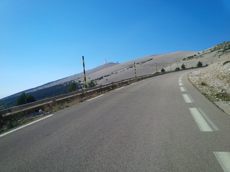
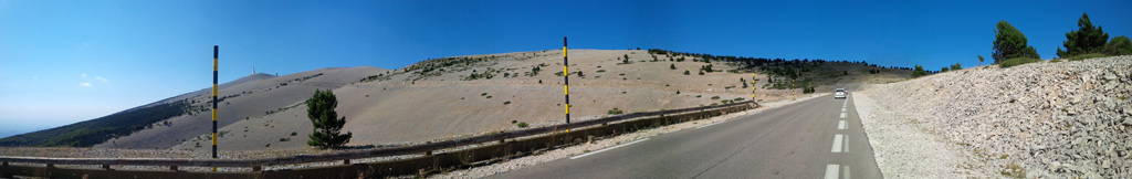
After taking the right turn at the end of the first bend past the restaurant, you might feel as though you’ve landed on the moon. If you were to snap a black-and-white photograph here—perhaps with a few futuristic helmets and fire extinguishers in the background—it could easily pass as a scene from a short sci-fi film or a swedish-french music video clip. The landscape is utterly desolate, painted only in shades of gray and white. As the ascent grows steeper, the wind intensifies, and the sun beats down relentlessly. Yet, for me, the heat was the last thing on my mind. I was too captivated by the view, with the lunar landscape stretching out to my right and a breathtaking panorama of Provence unfolding to my left.
Some cyclists report feeling a significant loss of power in this section, as the thinning air makes each pedal stroke more laborious. Personally, I didn’t notice any considerable drop in performance.
Just as you’re nearing the summit, you’ll come across a memorial dedicated to British cyclist Tom Simpson on your right-hand side. Tragically, he collapsed here during the 1976 Tour de France, long before my time, and it was later discovered that he’d been consuming a cocktail of Cognac and amphetamines at the time. While his actions are undoubtedly a cautionary tale about the darker aspects of professional cycling, I believe that – in death – Tom Simpson has become a poignant reminder of how fleeting life can be.
I left my water bottle at your memorial, a bottle that had accompanied me through Germany, Belgium, the Netherlands, Denmark, and, of course, France. Around your tribute, there are several smaller memorials whose stories remain a mystery to me.
You must stop here.. #
..even if you are on a timed lap.
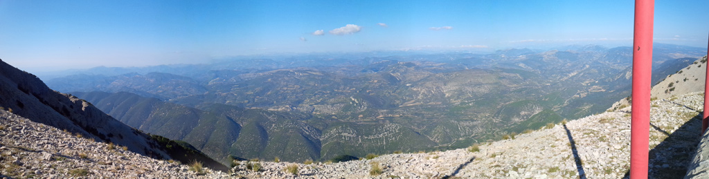
600 metres before the summit, the road takes a bend to the left, exposing an overwhelming view on the Provence on the right and the Alps on the horizon. I will not even try to describe it in more detail, just let me point out that if you want to have the impression of piloting a glider around the Alps, this is the right place.
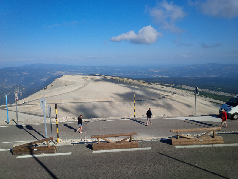
The summit and the descent #
Up the last bend, the famous right turn, and up you are. Congratulations, enjoy the view! You might even change clothing to something windproof, as there will be a 21km descent waiting for you, which will easily result in speeds above 100km/h. I highly recommend to check tires and brakes before and after the descent and practice cornering before going to Mont Ventoux, as I am sure no brake, regardless of its type, not even disc brakes, will stand the descent if you are not skilled in cornering and technical braking.